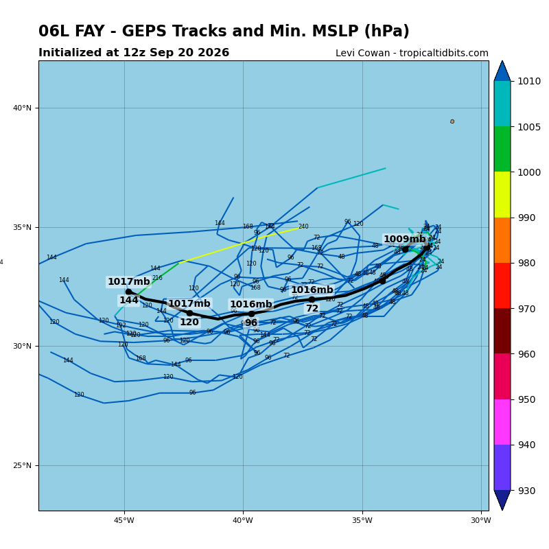
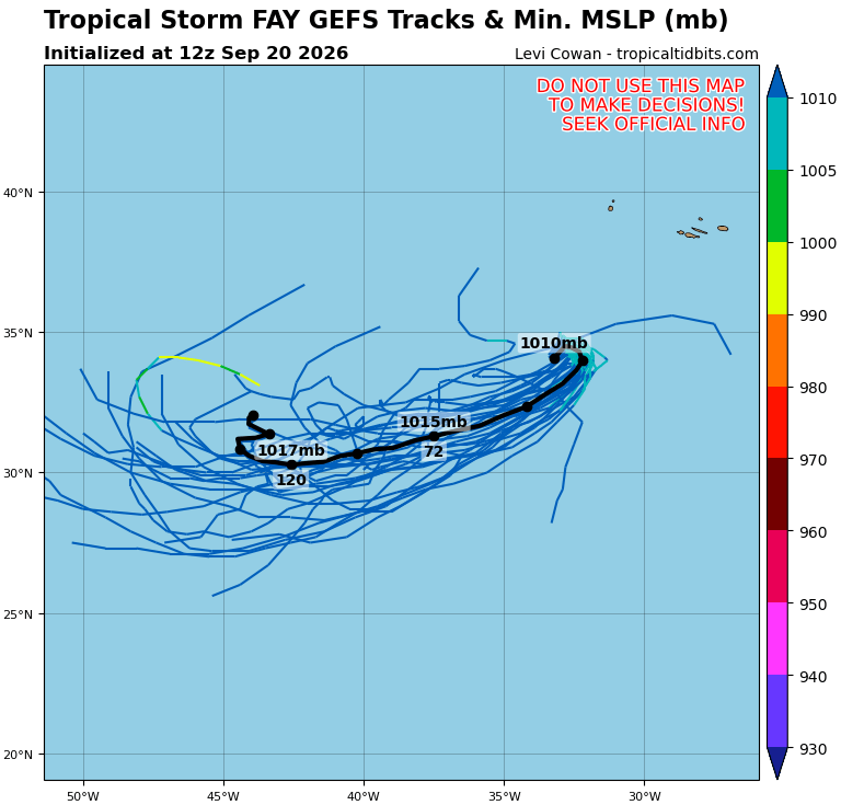
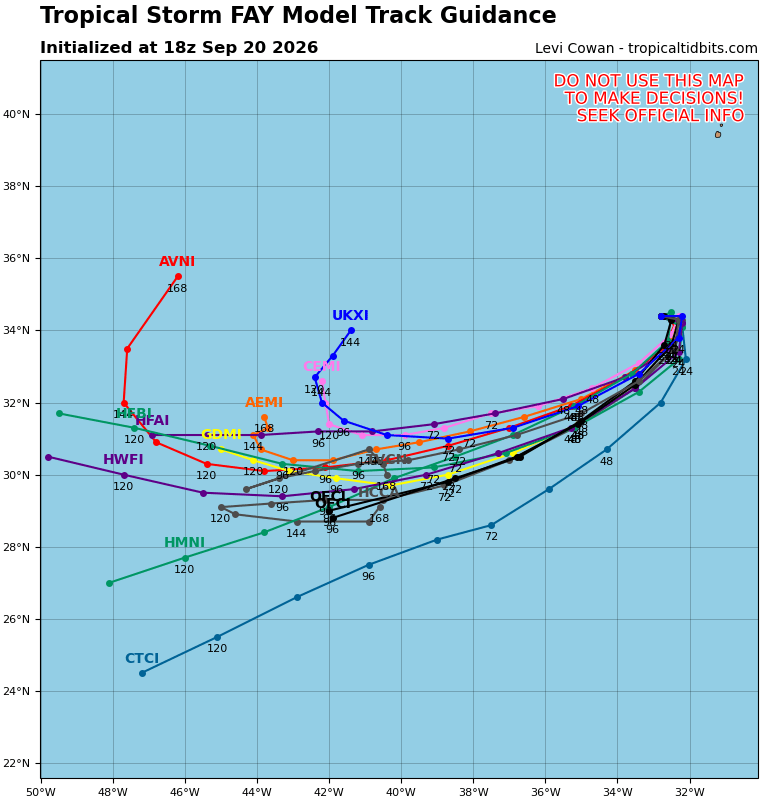
Array
(
[@attributes] => Array
(
[version] => 2.0
)
[channel] => Array
(
[pubDate] => Sun, 20 Sep 2026 21:49:40 GMT
[title] => NHC Atlantic
[description] => Active tropical cyclones in the Atlantic, Caribbean, and the Gulf of America
[link] => https://www.nhc.noaa.gov/
[copyright] => none
[managingEditor] => nhcwebmaster@noaa.gov (NHC Webmaster)
[language] => en-us
[webMaster] => nhcwebmaster@noaa.gov (NHC Webmaster)
[image] => Array
(
[url] => https://www.nhc.noaa.gov/gifs/xml_logo_nhc.gif
[link] => https://www.nhc.noaa.gov/
[title] => NHC Atlantic
[description] => NOAA logo
[width] => 95
[height] => 45
)
[item] => Array
(
[0] => Array
(
[title] => Atlantic Tropical Weather Outlook
[description] => Array
(
)
[pubDate] => Sun, 20 Sep 2026 17:39:52 GMT
[link] => https://www.nhc.noaa.gov/gtwo.php?basin=atlc
[guid] => https://www.nhc.noaa.gov/gtwo.php?basin=atlc&202609201739
[author] => nhcwebmaster@noaa.gov (NHC Webmaster)
)
[1] => Array
(
[title] => Summary for Tropical Storm Fay (AT1/AL062026)
[guid] => summary-al062026-202609202034
[pubDate] => Sun, 20 Sep 2026 20:34:27 GMT
[author] => nhcwebmaster@noaa.gov (NHC Webmaster)
[link] => https://www.nhc.noaa.gov/text/refresh/MIATCPAT1+shtml/202034.shtml
[description] => ...FAY CONTINUES TO STRENGTHEN AND COULD REACH HURRICANE STATUS... As of 9:00 PM GMT Sun Sep 20 the center of Fay was located near 34.4, -32.7 with movement NNE at 6 mph. The minimum central pressure was 999 mb with maximum sustained winds of about 65 mph.
)
[2] => Array
(
[title] => Tropical Storm Fay Public Advisory Number 6
[description] => Issued at 900 PM GMT Sun Sep 20 2026 000
WTNT31 KNHC 202034
TCPAT1
BULLETIN
Tropical Storm Fay Advisory Number 6
NWS National Hurricane Center Miami FL AL062026
900 PM GMT Sun Sep 20 2026
...FAY CONTINUES TO STRENGTHEN AND COULD REACH HURRICANE
STATUS...
SUMMARY OF 900 PM GMT...2100 UTC...INFORMATION
----------------------------------------------
LOCATION...34.4N 32.7W
ABOUT 405 MI...650 KM SW OF THE AZORES
MAXIMUM SUSTAINED WINDS...65 MPH...100 KM/H
PRESENT MOVEMENT...NNE OR 20 DEGREES AT 6 MPH...9 KM/H
MINIMUM CENTRAL PRESSURE...999 MB...29.50 INCHES
WATCHES AND WARNINGS
--------------------
There are no coastal watches or warnings in effect.
DISCUSSION AND OUTLOOK
----------------------
At 900 PM GMT (2100 UTC), the center of Tropical Storm Fay was
located near latitude 34.4 North, longitude 32.7 West. Fay is moving
toward the north-northeast near 6 mph (9 km/h) this general motion
is expected to continue through the rest of the day. Afterwards a
turn to the southwest is expected on Monday.
Maximum sustained winds have increased to near 65 mph (100 km/h)
with higher gusts. Additional strengthening is forecast tonight,
and Fay could approach hurricane intensity. A gradual weakening
trend is expected to begin on Monday.
Tropical-storm-force winds extend outward up to 45 miles (75 km)
from the center.
The estimated minimum central pressure is 999 mb (29.50 inches).
HAZARDS AFFECTING LAND
----------------------
None
NEXT ADVISORY
-------------
Next complete advisory at 300 AM GMT.
$$
Forecaster Katz/Pasch
[pubDate] => Sun, 20 Sep 2026 20:34:27 GMT
[link] => https://www.nhc.noaa.gov/text/refresh/MIATCPAT1+shtml/202034.shtml
[guid] => https://www.nhc.noaa.gov/text/refresh/MIATCPAT1+shtml/202034.shtml
[author] => nhcwebmaster@noaa.gov (NHC Webmaster)
)
[3] => Array
(
[title] => Tropical Storm Fay Forecast Advisory Number 6
[description] => Issued at 2100 UTC SUN SEP 20 2026 000
WTNT21 KNHC 202033
TCMAT1
TROPICAL STORM FAY FORECAST/ADVISORY NUMBER 6
NWS NATIONAL HURRICANE CENTER MIAMI FL AL062026
2100 UTC SUN SEP 20 2026
TROPICAL STORM CENTER LOCATED NEAR 34.4N 32.7W AT 20/2100Z
POSITION ACCURATE WITHIN 20 NM
PRESENT MOVEMENT TOWARD THE NORTH-NORTHEAST OR 20 DEGREES AT 5 KT
ESTIMATED MINIMUM CENTRAL PRESSURE 999 MB
MAX SUSTAINED WINDS 55 KT WITH GUSTS TO 65 KT.
50 KT....... 20NE 20SE 0SW 0NW.
34 KT....... 40NE 40SE 0SW 0NW.
4 M SEAS.... 60NE 0SE 0SW 0NW.
WINDS AND SEAS VARY GREATLY IN EACH QUADRANT. RADII IN NAUTICAL
MILES ARE THE LARGEST RADII EXPECTED ANYWHERE IN THAT QUADRANT.
REPEAT...CENTER LOCATED NEAR 34.4N 32.7W AT 20/2100Z
AT 20/1800Z CENTER WAS LOCATED NEAR 34.4N 32.8W
FORECAST VALID 21/0600Z 34.3N 32.3W
MAX WIND 65 KT...GUSTS 80 KT.
64 KT... 10NE 10SE 0SW 0NW.
50 KT... 20NE 20SE 0SW 0NW.
34 KT... 40NE 40SE 20SW 30NW.
FORECAST VALID 21/1800Z 33.6N 32.5W
MAX WIND 55 KT...GUSTS 65 KT.
50 KT... 0NE 0SE 10SW 0NW.
34 KT... 30NE 20SE 20SW 20NW.
FORECAST VALID 22/0600Z 32.5N 33.5W
MAX WIND 45 KT...GUSTS 55 KT.
34 KT... 30NE 20SE 20SW 20NW.
FORECAST VALID 22/1800Z 31.4N 35.1W
MAX WIND 35 KT...GUSTS 45 KT.
34 KT... 20NE 0SE 0SW 20NW.
FORECAST VALID 23/0600Z 30.5N 36.8W...POST-TROP/REMNT LOW
MAX WIND 30 KT...GUSTS 40 KT.
FORECAST VALID 23/1800Z 29.8N 38.7W...POST-TROP/REMNT LOW
MAX WIND 25 KT...GUSTS 35 KT.
EXTENDED OUTLOOK. NOTE...ERRORS FOR TRACK HAVE AVERAGED NEAR 125 NM
ON DAY 4 AND 175 NM ON DAY 5...AND FOR INTENSITY NEAR 15 KT EACH DAY
OUTLOOK VALID 24/1800Z 29.0N 42.0W...POST-TROP/REMNT LOW
MAX WIND 25 KT...GUSTS 35 KT.
OUTLOOK VALID 25/1800Z...DISSIPATED
REQUEST FOR 3 HOURLY SHIP REPORTS WITHIN 300 MILES OF 34.4N 32.7W
NEXT ADVISORY AT 21/0300Z
$$
FORECASTER KATZ/PASCH
[pubDate] => Sun, 20 Sep 2026 20:33:56 GMT
[link] => https://www.nhc.noaa.gov/text/refresh/MIATCMAT1+shtml/202033.shtml
[guid] => https://www.nhc.noaa.gov/text/refresh/MIATCMAT1+shtml/202033.shtml
[author] => nhcwebmaster@noaa.gov (NHC Webmaster)
)
[4] => Array
(
[title] => Tropical Storm Fay Forecast Discussion Number 6
[description] => Issued at 900 PM GMT Sun Sep 20 2026 000
WTNT41 KNHC 202035
TCDAT1
Tropical Storm Fay Discussion Number 6
NWS National Hurricane Center Miami FL AL062026
900 PM GMT Sun Sep 20 2026
A few more convective bursts have occurred near the center of Fay in
the last couple of hours as seen in the visible satellite imagery.
Infrared satellite imagery indicates that some of the cloud tops
have cooled to near -70 degrees C with the latest batch of
convection. The current objective intensity estimates from UW-CIMSS
are in the range of 45-51 kt, and the most recent TAFB Dvorak fix
was a T3.5/55 kt. Based on the given data, the initial intensity has
been raised to 55 kt, on the upper end of the satellite estimates.
The environment that Fay is located in still has moisture for
additional convective development and an approaching mid- to
upper-level trough should allow for Fay to further intensify for
about 12 hours or so. Once the trough lifts on Monday, wind shear
should increase and dry air should find its way into the cyclone.
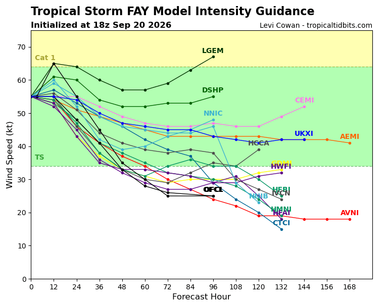
This will lead to a gradual weakening of Fay. The current NHC
intensity forecast calls for Fay to become a post-tropical remnant
low by Tuesday and then dissipate near the end of the week. The
intensity forecast is still a little higher than the model guidance
in the short term as Fay's structure is over performing expectations
due to the expected baroclinic support from the trough. It is still
possible that Fay could reach hurricane strength sometime tonight.
Fay is still moving slowly and off toward the north-northeast, with
the initial motion estimated around 020/5 kt. This general motion is
expected to continue for about 12 hours or. However, a low- to
mid-level ridge is expected to build to the north by Monday. This
ridge in turn will force Fay to turn southwestward and gradually
accelerate over the course of the forecast period. The current NHC
forecast track is similiar to the previous track forecast with a few
minor adjustments and remains in good agreement with the HCCA and
GDMI track aids.
FORECAST POSITIONS AND MAX WINDS
INIT 20/2100Z 34.4N 32.7W 55 KT 65 MPH
12H 21/0600Z 34.3N 32.3W 65 KT 75 MPH
24H 21/1800Z 33.6N 32.5W 55 KT 65 MPH
36H 22/0600Z 32.5N 33.5W 45 KT 50 MPH
48H 22/1800Z 31.4N 35.1W 35 KT 40 MPH
60H 23/0600Z 30.5N 36.8W 30 KT 35 MPH...POST-TROP/REMNT LOW
72H 23/1800Z 29.8N 38.7W 25 KT 30 MPH...POST-TROP/REMNT LOW
96H 24/1800Z 29.0N 42.0W 25 KT 30 MPH...POST-TROP/REMNT LOW
120H 25/1800Z...DISSIPATED
$$
Forecaster Katz/Pasch
[pubDate] => Sun, 20 Sep 2026 20:35:25 GMT
[link] => https://www.nhc.noaa.gov/text/refresh/MIATCDAT1+shtml/202035.shtml
[guid] => https://www.nhc.noaa.gov/text/refresh/MIATCDAT1+shtml/202035.shtml
[author] => nhcwebmaster@noaa.gov (NHC Webmaster)
)
[5] => Array
(
[title] => Tropical Storm Fay Wind Speed Probabilities Number 6
[description] => Issued at 2100 UTC SUN SEP 20 2026 000
FONT11 KNHC 202034
PWSAT1
TROPICAL STORM FAY WIND SPEED PROBABILITIES NUMBER 6
NWS NATIONAL HURRICANE CENTER MIAMI FL AL062026
2100 UTC SUN SEP 20 2026
AT 2100Z THE CENTER OF TROPICAL STORM FAY WAS LOCATED NEAR LATITUDE
34.4 NORTH...LONGITUDE 32.7 WEST WITH MAXIMUM SUSTAINED WINDS NEAR
55 KTS...65 MPH...100 KM/H.
Z INDICATES COORDINATED UNIVERSAL TIME (GREENWICH)
ATLANTIC STANDARD TIME (AST)...SUBTRACT 4 HOURS FROM Z TIME
EASTERN DAYLIGHT TIME (EDT)...SUBTRACT 4 HOURS FROM Z TIME
CENTRAL DAYLIGHT TIME (CDT)...SUBTRACT 5 HOURS FROM Z TIME
WIND SPEED PROBABILITY TABLE FOR SPECIFIC LOCATIONS
CHANCES OF SUSTAINED (1-MINUTE AVERAGE) WIND SPEEDS OF AT LEAST
...34 KT (39 MPH... 63 KM/H)...
...50 KT (58 MPH... 93 KM/H)...
...64 KT (74 MPH...119 KM/H)...
FOR LOCATIONS AND TIME PERIODS DURING THE NEXT 5 DAYS
PROBABILITIES FOR LOCATIONS ARE GIVEN AS OP(CP) WHERE
OP IS THE PROBABILITY OF THE EVENT BEGINNING DURING
AN INDIVIDUAL TIME PERIOD (ONSET PROBABILITY)
(CP) IS THE PROBABILITY OF THE EVENT OCCURRING BETWEEN
18Z SUN AND THE FORECAST HOUR (CUMULATIVE PROBABILITY)
PROBABILITIES ARE GIVEN IN PERCENT
X INDICATES PROBABILITIES LESS THAN 1 PERCENT
PROBABILITIES FOR 34 KT AND 50 KT ARE SHOWN AT A GIVEN LOCATION WHEN
THE 5-DAY CUMULATIVE PROBABILITY IS AT LEAST 3 PERCENT.
PROBABILITIES FOR 34...50...64 KT SHOWN WHEN THE 5-DAY
64-KT CUMULATIVE PROBABILITY IS AT LEAST 1 PERCENT.
- - - - WIND SPEED PROBABILITIES FOR SELECTED LOCATIONS - - - -
FROM FROM FROM FROM FROM FROM FROM
TIME 18Z SUN 06Z MON 18Z MON 06Z TUE 18Z TUE 18Z WED 18Z THU
PERIODS TO TO TO TO TO TO TO
06Z MON 18Z MON 06Z TUE 18Z TUE 18Z WED 18Z THU 18Z FRI
FORECAST HOUR (12) (24) (36) (48) (72) (96) (120)
- - - - - - - - - - - - - - - - - - - - - - - - - - - - - - - - - -
LOCATION KT
$$
FORECASTER KATZ/PASCH
[pubDate] => Sun, 20 Sep 2026 20:34:54 GMT
[link] => https://www.nhc.noaa.gov/text/refresh/MIAPWSAT1+shtml/202034.shtml
[guid] => https://www.nhc.noaa.gov/text/refresh/MIAPWSAT1+shtml/202034.shtml
[author] => nhcwebmaster@noaa.gov (NHC Webmaster)
)
[6] => Array
(
[title] => Tropical Storm Fay Graphics
[description] => Array
(
)
[pubDate] => Sun, 20 Sep 2026 21:23:07 GMT
[link] => https://www.nhc.noaa.gov/refresh/graphics_at1+shtml/212307.shtml?cone
[guid] => https://www.nhc.noaa.gov/refresh/graphics_at1+shtml/212307.shtml?cone
[author] => nhcwebmaster@noaa.gov (NHC Webmaster)
)
)
)
)